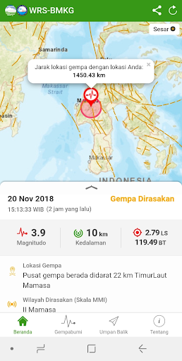
The WRS-BMKG application aims to disseminate information on earthquakes M ≥ 5.0, tsunamis and felt earthquakes that occur especially in the Indonesian region.This application is provided for BMKG stakeholders such as BNPB, BPBD, Regional Government, radio media, television media, TNI, POLRI, other Ministries/State Institutions and private parties, so that they can get the easiest way to receive information from the BMKG Indonesian Tsunami Warning System (InaTEWS). Indonesia.Application features:1. Map2. List of the last 30 events for each: earthquake M ≥ 5.0, tsunami, and felt earthquake3. Shakemap4. Map of estimated tsunami arrival time5. Map of estimated maximum sea level height6. Map of estimated warning levels in the warning zone7. Tabular warning level estimates8. Tsunami early warning sequence9. Distance from the epicenter to the users location10. MMI information for areas that felt the earthquake for the earthquake felt11. Suggestions and directions from BMKG12. Age of earthquake occurrence13. Sound notifications and pop-up alerts14. Share information15. Fault plot16. Link to BMKG explanation/Press Release17. User feedback18. Glossary© InaTEWS-BMKG IndonesiaBuilding C, 2nd Floor, BMKG CenterJl. Space 1 No. 2 Kemayoran, Jakarta, Indonesia 10610Web & Email Services AdminCommunication Network CenterDeputy for Instrumentation, Calibration, Engineering and Communication NetworksMeteorology Climatology and Geophysics CouncilTel: +62 21 4246321 ext. 1513Fax: +62 21 4209103Email:
[email protected]: www.bmkg.go.id