
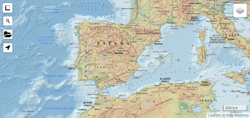
The app allows quick, simple and fluid visualization on mobile devices of different types of cartography.
The maps that we can upload online are the following:- Topographic maps of Spain offered by the National Geographic Institute (IGN) at different scales (1:10,000,000, 1:2,000,000, 1:500,000, 1:200,000, 1:50,000, 1;25,000)- Map of the Open Street Map collaborative project where users themselves map the world (Open Topo Map, MTB map Europe, CycloOSM, Public Transport)- Most current aerial photographs of Spain from the PNOA plan- The different existing historical orthophoto flights (PNOA from 2004 to 2022, SIGPAC 1997-2003, OLISTAT0 1997-1998, National Flight 1981-1986, Interministerial Flight 1973-1986, American Flight Series B, 1956-1957)- The IGN base cartography with geographic information from different cartographic sources- CEGET military maps: Military raster map at a scale of 1:1,000,000 with hypsometric inks, Military raster topographic map at a scale of 1:100,000 edited from the BTN100 with contour lines every 40 m (Series M682), and 3 layers of topographic maps at a scale of 1:50,000 with contour lines every 20 m with the L series symbols (Series P713, M7814 and M7815).- Some of the regional cartographic services: Institut Cartogràfic Valencià (ICV), Institut Cartografic i Geologic de Catalunya (ICGC), Territorial Information System of Navarra (SITNA), Cantabria, Andalusia (IECA), Canary Islands (GRAFCAN), Information Center Territorial of the Junta de Castilla y León, Institut Cartogràfic i Geogràfic de les Illes Balears (ICGIB), Basque Country- Cadastral cartography of the General Directorate of Cadastre (Zoom >= 300m)- Geological cartography of the Geological and Mining Institute of Spain (IGME) at a scale of 1/50,000- Traces made by users of the Strava application- Waymarked Trails hiking, MTB and biking trailsIn addition, the application has different tools such as GPS geolocation to use in field trips, with the option to activate tracking, distance meter and introduction of GPX, KML and GeoJson files.The cartography is obtained by taking advantage of the services offered by each institution or organization online (using data or Wi-Fi).
Once viewed, the maps are stored in cache and can be consulted offline in places without coverage.It also allows you to view the border lines of the different administrations that make up the map of Spain.
With it we can locate both the layout of the municipal boundaries, as well as the limits between Autonomous Communities or the borders of the country.
To do this, it uses the data provided by the National Cartographic Institute and the General Directorate of the Cadastre.
The first on a broad scale and the second on a very detailed level.
It will help us locate the places where the administrative limits that have historically drawn the borders of the territory run.The application is designed for easy, quick and simple cartographic visualization.
Without the need for prior cartographic knowledge.Web:https://www.geamap.com/es/espana
https://andro.io/app/visor-1dkrg
 Power 100



Android app profile
Cartografía de España for Android – Latest Version & Features
by Rodeno
★★★★★
(0 ratings)
Rate this app
How do you feel about Cartografía de España?
Thanks for your feedback!
> 2.2k
Monthly Downloads
~$900
Estimated Cost
Screenshots