
This hunting GPS app provides access to property line maps, parcels & publiclands, land ownership details.
Map layers for 50+ states include huntingzones, restricted areas, possible access areas, state refgues and more.Vector topo maps with most accurate USGS elevation contours, hiking & bikingtrails.
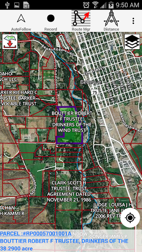
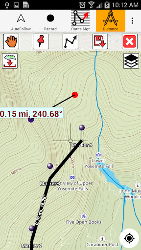
Coverage includes all US states.► Vector Topo Maps√ Beautiful & detailed Hardware/GPU accelerated vector maps (text stays upright on rotation)√ Vector USGS contours (Change height to ft or meter).√ Covers popular hiking & biking trails and paths► Parcel Maps√ Includes following ownerhsip attributes (where available)* Owner name and Owner address* Site Address* Parcel ID Total Value► Hunt Planning maps√ Possible Public Access√ Public lands and Parcels√ Hunting Zones√ Game Distribution√ Restricted Ares√ Portions► Offline vector maps√ Easy to download offline topos► PLSS maps√ PLSS Townships and Sections (US Wide coverage)► Custom base maps√ Switch base maps between vector topos, hybrid satellite imagery and more►GPS FEATURES√ Record Tracks√ Enter or import Waypoints.√ Auto Follow* Real Time Track Overlay* Predicted Path Vector* Course Up(Text stays upright)* Speed & Heading√ Route Assistance With Voice Prompts* Prompts when approaching a boating route marker* Continous distance & ETA updates* Alerts when off route* Alerts when moving in wrong direction►ROUTE MANAGEMENT / TRIP PLANNING√ Create New Route/Edit Existing Routes√ Move Points√ Add points to an existing route leg√ Delete / Rename points√ Import GPX,KML & KMZ files√ Plot/Edit Routes √ Enter Waypoints√ Share/Export Routes,Tracks&Markers√ Reverse Routes► SHARING* Share tracks/routes/markers on Facebook & Twitter* Export tracks/routes/markers as compressed GPX files.► Topo & Trail Maps for National ParksDetailed topographic trail maps are included for national and state park including::√ Great Smoky Mountains√ Grand Canyon√ Zion√ Rocky Mountain√ Yosemite√ Yellowstone√ Acadia√ Olympic√ Denali√ Glacier► Suggested Uses for i-Hunting Topo Maps√ Hunt Planning & Recon√ Off trail and On trail hiking√ Backpacking : Use Topos of National Forests and Wilderness areas with GPS√ Snow Sports (Snow Shoeing, Skiing, Snowboarding, Snow Mobiling)√ SAR (Search and Rescue)The i-Hunting application can turn your phone into full fledged outdoors GPS unit (like Garmin ® or Magellan ® outddor GPS).
The app compliments the gear you got from Dicks ® , REI ® , Cabelas ® etc.
https://andro.io/app/topo-android-market
 Power 100


Android app profile
Hunting Gps Maps w/ Property L for Android – Latest Version & Features
★★★★★
(0 ratings)
Rate this app
How do you feel about Hunting Gps Maps w/ Property L?
Thanks for your feedback!
> 2.2k
Monthly Downloads
~$900
Estimated Cost
Screenshots


