
This application is intended for pilots of light airplanes, microlights and users of computer simulators.
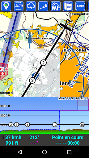
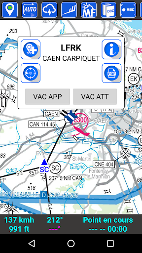
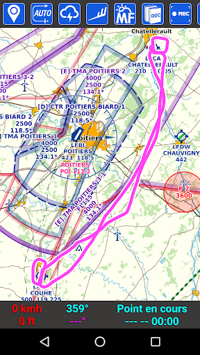
It covers mainland France and partially overseas.Feature lists:- GPS tracking of the device: Position, ground speed, heading, altitude- Vector speed with bubbles or dashes of time- Management of the current navigation point (heading to be taken / time remaining)- Choice of display of wind & drift, height, or arrival time at destination- Intelligent self-centering of the map- North-true modes or direction of the device- Quick "Direct" function- The "Direct" function allows you to search for towns, villages (if connected)- Automatic recording of your flight tracks (visualization directly in SDVFR or export to KML or GPX formats)- Easily embed all SIA documentation (VAC, VAC HELI, AIP, SUP AIP, AZBA)- Easy access to VFR & weather guides, supplement to maps, legends- Geo-referenced VAC placed on the base map (approach, turn of the track, taxiways & car parks)- Geo-referenced AIP SUP (see areas from AIP SUPs directly on the map)- Weather messages: METAR, TAF, SIGMET (decoding, colors, wind alert, graphic sigmets)- Widget "My station" to quickly view your favorite METAR & TAF without launching the application- Position and information of airports / aerodromes / heliports / ULM bases (http://basulm.ffplum.info)- View wintems on 18 different levels (FL005 to FL150) over 24 hour forecasts- Direct access to Météo-France maps (Wintem & Temsi)- Aeronautical cards: IGN 500K, SIA 250K, CartaBossy, Editerra Air Million (paying)- SDOACI France & Corsica aeronautical map (free)- SIA million maps & cruises, OpenStreetMap, IGN Road scan 1M / 250K road (free)- Display multiple cards in the order you want- Paid option to use your own cards (mbtiles format)- Automatic synchronization of planes, navigations and maps between your terminals- On-demand synchronization of your flight tracks- Notams of aerodromes and FIR- Dynamic AZBA function- VFR reporting points- Dynamic profile (sectional view of the air spaces in front of you)- Easily build a navigation and see the corresponding nav log- Associate frequencies on its navigation log- Automatic calculation of drift and effective wind, weather with wind- Theoretical calculation of ascents / descents- Manage a list of devices with their characteristics- "Flight file" screen: Land, Notams, METAR, TAF on your route- Complete navigation profile (relief & airspaces crossed)- View an airspace and its information easily via a double-tap on the map- Manage your browsing (PDF export, save, print, send by email)- Import / Export of navigations or tracks in GPX format- Export of navigations in PLN format for FSX or P3D- Export of navigations in FPL format for Garmin- Edit fuel quotes (PDF export, printing, sending by email)- Screen of masses and centering- Modifiable units (altitude, distance, speed)- Customization of line thicknesses and colors (navigation, speed vector, track)- VOR / NDB overlaps- Management of personalized points (UserWaypoints)- Display KML files on the map- Two stopwatches- Magnetic variation taken into account- Application designed for non-connected use- Uses official data from the AIS- Automatic update (AIRAC cycle every 28 days)- Connection to a simulator (FS2020, FSX, P3D, X-Plane, FlightGear, AeroFly)- Connection to a traffic detection unit (GDL90 or Flarm NMEA via Wifi)- System of "notams" to be informed on the state of health of the application- Store personal PDF files in Document Explorer- GUND correction to refine the altitude provided by the GPS
https://andro.io/app/sdvfr
 Power 100

Android app profile
SDVFR for Android – Latest Version & Features
by SkyDreamSoft
★★★★★
(0 ratings)
Rate this app
How do you feel about SDVFR?
Thanks for your feedback!
> 2.2k
Monthly Downloads
~$900
Estimated Cost
Screenshots


