


An ultimate navigation application for all outdoor enthusiasts - hikers, mountain bikers, mountaineers, trail runners, or geocachers.
And not only for them, but Locus Map 3 Classic (formerly Locus Map Pro) is widely used also by professionals - explorers, travelers, or rescue squads all over the world.Locus Map 3 Classic offers true multi-functionality and flexibility:• advanced navigation capability, supporting online and offline routing services• unprecedented choice of premium offline and online maps• advanced map tools - map overlays, offsets, WMS sources support• tools for monitoring sports activities - tracking, audio coach, charts, statistics, support of external sensors (GPS, HRM, cadence...)• worldwide weather forecast 24/7• sophisticated tools for geocaching • graphic and calculation tools, online/offline logging, support of trackables, Pocket Queries, spoilers…Map portfolioOffline maps• LoMaps - OSM-based vector maps of the whole world.
Containing themes for hiking, biking, winter sports, road or city use - three LoMaps are for free• Maps of renowned cartographic publishers: • Germany, Austria, Italy - Kompass, Outdooractive Summer and Winter, Freytag-Berndt hiking maps• United States - Accuterra trail maps• Switzerland - SwissTopo• United Kingdom - Ordnance Survey (eq.
to Landranger and Explorer)• France - IGN topo and satellite• Spain - CNIG• Poland - Compass hiking maps• Czechia, Slovakia - SHOCart• other countries - PZS Slovenia, IGN Belgium, Cartographia Hungary, etc.• support of external maps in SQLite, TAR, MBT, GEMF, Orux, or RMAP formatsOnline maps• World - various OSM based maps• US - USGS, ChartBundle• Europe - Outdooractive Summer and Winter, Freytag-Berndt, IGN France and Belgium, Kapsi.fi, Turistautak, Cartographia, Skoterleder, Statkart, Retromap (Russia), UMP and Osmapa.pl (Poland) and many others• Asia etc.
- GSI (Japan), Visicom (former Soviet countries), Navigasi (Indonesia), NzTopoMaps (New Zealand)...Most of the online maps can be DOWNLOADED for offline use.
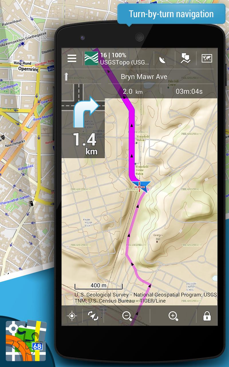
WMS maps• meteorological maps, NASA maps, cadastral maps...Features:Navigation and guidance• turn-by-turn voice navigation with support of online/offline routing services• beeline guidance to a point (on the map or by compass) or along a route with notificationsTracks&Routes• multi-profile track recording• charts&statistics• audio coach for efficient workouts• support of Bluetooth/ANT+ external sensors - HRM, speed/cadence, GPS, NMEA• route planning and editing tools• import/export of routes/tracks from/to various formats (KML, KMZ, GPX...) and web services (Strava, Runkeeper, Google Earth, etc...)• customizable bike computer dashboardPoints• creating own database - filtering, search, sorting• import/export in many formats, web services support• LoPoints - database of OSM POIsMap tools• map overlay, calibration, and offsets• support of various external map formats and coordinate systems• support of geotagged photos, OSM notesSearch• addresses online and offline• W3W addresses• LoPoints, GeoNames, GNS, and WikipediaGeocaching• downloading geocaches via Geocaching4Locus add-on• offline and online logging• support of waypoints, PocketQuery, trackables, spoilers• graphic and calculation toolsLive tracking• private or public sharing/monitoring of location in real-timeOther features and tools• parking assistant, worldwide weather forecast, QR code generator...Locus Map 3 Classic is highly customizable.
Everything can be set according to the users needs - the main menu, function panels, dashboards, custom screens...
The functionality of the app can be further extended by numerous add-ons - Locus Map Watch, Pebble, RFLKT (connecting with wearables), Augmented reality, GeoGet, Munzee, etc.This application uses device administrator permission.*** Locus Map Classic 3.60 ***A lot of tiny improvements and bug fixes across the whole app.
E
5
★
★
★
★
★
very handy to find your way back when bush walking - no getting lost as you can easily retrace your steps. keeping a record of distance covered, height, speed when on holiday was a great way to journal our trips. battery usage is low as well. got maps of New Zealand. I recommend.


