

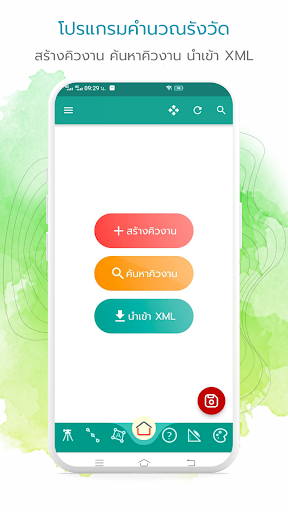
iCAD is an application.
For calculating surveying workHelps calculate land surveying in the field.
Convenient, easy to use, supports work on all mobile devices.
No need to carry a notebook into the surveying area anymore.
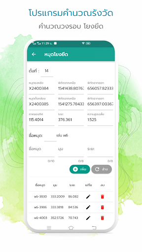
Able to exchange surveying calculation data in XML format with surveying calculation program (DOLCAD) or send surveying calculation files to relevant persons via Line, Facebook, email or others.In addition, the plot can be displayed on a Google Map map.Program functions- Main menu- Create a work queue- Search for work queues- Import XML, RTK, GPS files- Import boundary markers- Files from the theodolite- Export XML file- Export markers- Backup dataCalculate- Circle pin- Floating pins- Fastening pins- Old circle pin- Old boundary markerONLINE- Interval distance- walking distance- Parallel- Extract scenes- perpendicular- intersection point- Limited area to 1 point.- Limited area to 2 points.- Move the entire lineforming a plot- Combined plots- Separate plot- Fixed conversion- Subdivision plot etc.- Convert title deed- Convert to a deed of dedicationquery- distance, sector of direction- Angle, distance, sector of direction- 2 consecutive points- 3 consecutive points- scene coordinates- Area- Search for pin names- Create a star-shaped anchor pin.Triangle work- Create a boundary marker- Scene coordinates- Region of direction, distance- distance, distance- mm, distance- angle, angledecorate- Move text, lines- Rotate text, lines- Side message- Draw lines- Separate boundaries- Data layer- Scale- Show land plot images, satellite pins on Google Map
https://andro.io/app/icad-17xpx


Rate this app
How do you feel about iCAD - แอปเพื่อคำนวณงานรังวัด?
Thanks for your feedback!
> 2.2k
Monthly Downloads
~$900
Estimated Cost
Screenshots


