
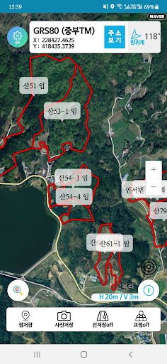
It supports the users location as GRS80 coordinates by utilizing the GPS of the smartphone, converts the polylines and text files of the CAD file to Lisp, and imports them from the app to check the location on the spot.
You can save points and photo movement paths and convert them to CAD files through Lisp, making it easy to edit and use.
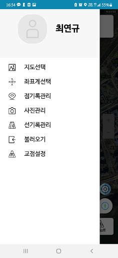
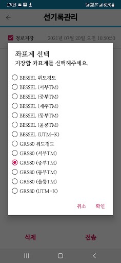
To use, download the app, sign up for Naver https://cafe.naver.com/skgps, and request a subscription application.map selection- Supports Naver-based general maps, satellite maps, topographic maps, cadastral maps, and hiking trail maps.coordinate system- It supports BESSEL coordinate system and GRS80 coordinate system, and it is possible to convert the coordinate system at once.point recordkeeping- You can save points and export them to mail or KakaoTalk, and Excel files and nerve files are supported.photo management- You can save photos and dots and export them to KakaoTalk, and Excel files and nerve files are supported.line record management- Lines are saved along the moving line so that you can check the track, and Excel files and nerve files are supported.There are import and vertex settings.
*Precautions* The coordinates in the app are not accurate and have errors.
It cannot be used for the survey of boundary coordinates, and it shows performance similar to GPS for general navigation.
When using this app, the smartphones battery may be discharged prematurely, and the location error increases if the apps screen is turned off in the background mode and if it is not easy to receive radio waves from a pocket, etc.
https://andro.io/app/gpsgeocoder
 Power 100

Android app profile
산경GPS for Android – Latest Version & Features
by skcp
★★★★★
(0 ratings)
Rate this app
How do you feel about 산경GPS?
Thanks for your feedback!
> 2.2k
Monthly Downloads
~$900
Estimated Cost
Screenshots


