
Estimation application downloads and cost
Description
All-In-One OfflineMaps+ offers you to access a wide range of maps.Bored to wait for maps to display? Once displayed, maps are stored and remain available, quickly, even with no network access.
• Want more than just roads on your maps? You will find what you need here;• Used to go to places with poor network coverage? Everything will stay available;• Used to go abroad? You won't be lost anymore;• Have a data allowance limit? It will reduce your usage.
This Plus version includes all features of the Standard version without ads, and supports import of professional GPS and geographic landmarks file formats (waypoints, routes, tracks, areas) like GPX, Google Earth KML/KMZ (map overlays not supported), OziExplorer WPT, CVS/TSV and Geocaching LOC
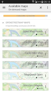
★★ Maps ★★A lot of maps are available, including classical road maps, topographic maps, aerial (satellite) maps and various layers that can be added over any maps: OpenStreetMap (Roads, Topo), Google Maps, Bing Maps, USGS National Map (Hi-res topo, Aerial imagery), Worldwide Military Soviet topo maps, etc.• All maps can be stacked in layers, with precise opacity control.• Select and store large areas in few clicks.• Stored space is clear and can be easily deleted.
★★ Display, store and retrieve unlimited landmarks ★★You can add various items on the map such as waypoints, icons, routes, areas and tracks.You can easily manage them using the powerful SD-Card Landmarks Explorer.
★★ On-map GPS Localization & Orientation ★★Your real location and direction are clearly displayed on the map, which can be rotated to match your real orientation (depends on device capabilities).Easy turn on/off to save battery.
And also:• Metric, imperial and hybrid distance units;• GPS Latitude/Longitude and grid coordinate formats (UTM, MGRS, USNG, OSGB Grid, Irish Grid, Swiss Grid, Lambert Grids, DFCI Grid, QTH Maidenhead Locator System, ...);• Ability to import hundreds of coordinate formats from http://www.spatialreference.org;• On-map grids display;• Full screen map view;• Multi-touch zoom;• ...
★★ Need more? ★★If you are a real adventurer, try AlpineQuest GPS Hiking, the complete outdoor solution based on All-In-One OfflineMaps, loaded with a powerful GPS Location Tracker and more: http://www.alpinequest.net/google-play
Read more
• Want more than just roads on your maps? You will find what you need here;• Used to go to places with poor network coverage? Everything will stay available;• Used to go abroad? You won't be lost anymore;• Have a data allowance limit? It will reduce your usage.
This Plus version includes all features of the Standard version without ads, and supports import of professional GPS and geographic landmarks file formats (waypoints, routes, tracks, areas) like GPX, Google Earth KML/KMZ (map overlays not supported), OziExplorer WPT, CVS/TSV and Geocaching LOC
★★ Maps ★★A lot of maps are available, including classical road maps, topographic maps, aerial (satellite) maps and various layers that can be added over any maps: OpenStreetMap (Roads, Topo), Google Maps, Bing Maps, USGS National Map (Hi-res topo, Aerial imagery), Worldwide Military Soviet topo maps, etc.• All maps can be stacked in layers, with precise opacity control.• Select and store large areas in few clicks.• Stored space is clear and can be easily deleted.
★★ Display, store and retrieve unlimited landmarks ★★You can add various items on the map such as waypoints, icons, routes, areas and tracks.You can easily manage them using the powerful SD-Card Landmarks Explorer.
★★ On-map GPS Localization & Orientation ★★Your real location and direction are clearly displayed on the map, which can be rotated to match your real orientation (depends on device capabilities).Easy turn on/off to save battery.
And also:• Metric, imperial and hybrid distance units;• GPS Latitude/Longitude and grid coordinate formats (UTM, MGRS, USNG, OSGB Grid, Irish Grid, Swiss Grid, Lambert Grids, DFCI Grid, QTH Maidenhead Locator System, ...);• Ability to import hundreds of coordinate formats from http://www.spatialreference.org;• On-map grids display;• Full screen map view;• Multi-touch zoom;• ...
★★ Need more? ★★If you are a real adventurer, try AlpineQuest GPS Hiking, the complete outdoor solution based on All-In-One OfflineMaps, loaded with a powerful GPS Location Tracker and more: http://www.alpinequest.net/google-play
All-In-One Offline Maps + screenshorts