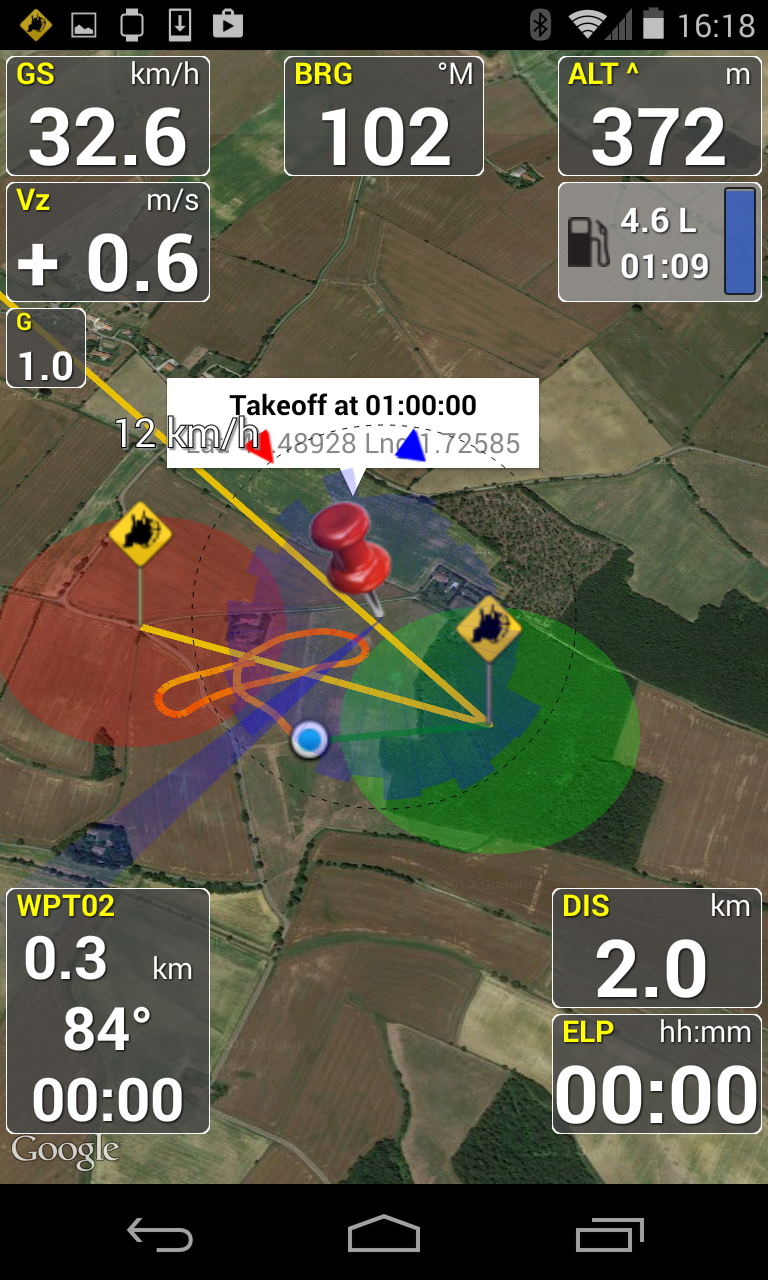
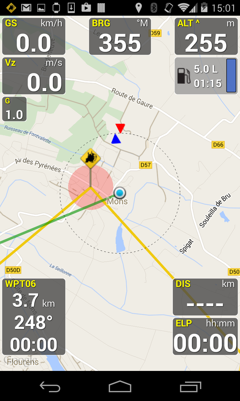
Welcome to PPGpS, a Flight Computer for Paramotor, Paraglider, Glider and Ultra Light plane Pilots.-Airspaces display-PPGpS can now display an Airspace overlay on the map. It is using OpenAir files that can be downloaded from the net and copied in the PPGpSairspaces folder.You may also use the AirspaceMap app to help you download some OpenAir files from various sources easily, and customize these large airspace maps to fit your needs, and then export them to the PPGpS airspace folder.*FEATURES OVERVIEW:-Real time flight information -Wind direction and speed estimation-Takeoff and Landing phases auto-detection-Return home information (display estimated travel time and bearing)-Fuel calculation and warning-Airspace display (OpenAir files)-Emergency geo-localized SMS-Barometric sensor support to improve altitude accuracy-QHN, QFE Altimeter setting-Online and offline maps-Offline maps creator-Google Maps and OpenStreetMap map providers-Rotating Map-Log flights in KML (for Google Earth), IGC (Leonardo servers) and GPX files-Replay recorded flights-Waypoint management -Especially developed for Paramotor-Embedded User Manual and Tip of the day feature.-Real time flight tracking on www.ppgps.info-Variometer-Sunset time-FlyNet2, Flight Bandit, BlueFlyVario and LK8Ex1 variometer support-Android Wear SmartWatch support with PPGpS Wear*MAPS:Online:PPGpS can display Google or OpenStreetMap maps in connected mode.Offline:Download map files in your smartphone in case you dont have an internet connection during the flight.Use the integrated PPGpS Offline Map Creator to generate offline maps.*INSTRUMENTS:PPGpS provides the altitude, vario, bearing, magnetic compass, acceleration and ground speed.With just one click on instruments you switch easily between different data modes : instantaneous, average and maximum values.Altimeter can be set to actual altitude or elevation (QHN, QFE) just by long-pressing on the altimeter.If your smartphone has a barometric sensor, it could be used to compute a very accurate altitude.You can use PPGpS Wear companion application to display your instruments on your SmartWatch.*WAYPOINTS:Create waypoints by tapping on the map or by entering their GPS coordinates.Select a waypoint with one click on the waypoint instrument (WPT).Rename or remove a waypoint from the contextual menu of the waypoint list.Follow the displayed route (bearing, estimated travel time and distance).Prepare your waypoints from Google Earth and import your KML files (PPGpS folder in the phone).Waypoints may be automatically loaded at startup and saved at the end of the session.In case your KML file doesnt import well, please send me the file and I will fix it quickly.*WIND AND SPEEDS HUD:The average ground speeds are graphically displayed for every azimuth.The wind direction is displayed (red arrow) and may be reset at any time during the flight.*RETURN HOME:Home direction and Estimated Travel Time to return home is always displayed (shaded red line).Computations are done according to the wind for accurate results.*LIVE TRACKING:Enable the Live Tracking feature to allow your friends and family to see you live on map ! Go to www.ppgps.info for more details.*AIRSPACE:Copy OpenAir files in the /ppgps/airspace folder to display airspaces on top of the mapUse my other app AirspaceMap to help you download and customize your openAir fileshttps://play.google.com/store/apps/details?id=com.ns31.airspacemapLaunch the Demonstration mode to have a quick tour.Visit http://www.ppgps.infoFind us on Facebook : https://www.facebook.com/ppgpsand Twitter : https://twitter.com/PPGpSAndroidEnjoy your flights with PPGpS and thank you for your
[email protected] 05/2021Support generic LK8Ex1 protocol for bluetooth altivariosTimestamps in KML track files for better replayBug fix on ReplayBug fix on Tip of the day1.58 04/2021Italian translation completedAirspace file parsing improvedFile security issue with Android 11 fixed1.57 04/2021Input Map and Waypoint name fixedElevation above ground crash fix1.56 09/2020Floating text color configurableLock the screen in portrait, landscape and inverted