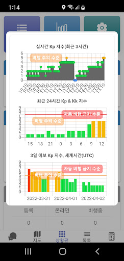
Drone aerial pest control/quarantine control scarecrow control app[Guide to main functions]• Group mode (for joint pest control): team play mode, single mode, real-time location sharing, real-time pest control agricultural work status• Personal mode (for personal business): Pest control agricultural work management mode for professional aerial pest control operators who control personal business volume.• Joint pest control real-time control: control information management such as plan/complete/incomplete/cancellation/site addition, statistics/progress rate, takeoff/landing/flight path by aircraft, and movement status of pest control personnel• National cadastral map: Provides the most optimized cadastral map for aerial pest control and edits user cadastral maps• Flight recorder: flight information, takeoff/landing detection and automatic pest control completion, pump signal recording/pest control density heat map• Text sending: automatic/reservation, manual, representative number sent (in case of joint pest control)• Agricultural land (scarecrow) registration: One-touch automatic registration and mass registration of Excel files• Pest control plan registration: Bulk registration in Excel file, automatic assignment and grouping task assignment• Pest control statistics: Pest control status output as Excel (csv) file• Voice guidance: Run the app in the background and listen only to the voice guidance (when using a flight recorder)• Provides real-time Earth magnetic field information and voice warning in case of high risk• Essential aviation pest control information Provides flight airspace information throughout Korea• Group talk dedicated to drone joint pest control• Satellite aerial pest control maps and cadastral maps are also provided for areas not serviced by domestic maps, such as the Ganghwa-gun area, northern Gyeonggi Province, and northern Gangwon Province.• Assistant mode: Provides the same app operation functions on the phone of the assistant pest control technician working with the pest control technician.• Location registration: Function to display location of apiary/water supply/restaurant/accommodation, etc.• Farm participation: Opening of real-time pest control field data to farms subject to pest control• Radio: Supports radio-based voice communication between group mode users• Pesticide search: Pesticide information provided by the Rural Development Administration• Create Excel file for submission of aviation pest control results to National Agricultural Products Quality Management Service[Guide to using device permissions]• Required permissions- Location (always allowed): Used to check my location and share movement routes when collaborating• Optional authority- Camera: Used to take proof shots at pest control sites- Storage space: Used to store certification shots and report files- Microphone: Used for walkie-talkie functions- Physical activity: Used to display avatars on the map- Stop optimizing battery usage: Necessary to ensure smooth communication even in the backgroundProject Raven Eyes PilotsSmart drone pest control app that surpasses aviation pest controlProducer: Winsgen