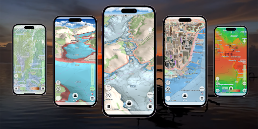
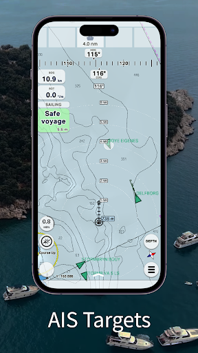
mKart is easy to install and use online marine navigation software (from creators of ECS/ECDIS dKart Navigator) with the fastest chart engine using hybrid ON/OFF sea maps concept and 3D nautical charts. Product Highlights:WEB CONSOLE:E-shop;ENCs and cartographic products Catalogue;Portfolio optimization;Fleet management;Roots and tracks;Data exchange;Accounting; SAFETY IS IN FOCUS:Automatic routing and NO-GO Area display;Dangerous depths and objects automatic control.Safe sailing alternative and recommendations;Meeting points and hazardous traverses calculations.Background monitoring: dangers’ and ships’ alerts, all along the route.Apple watch support. DOCKING:Click on the chart, select the location and follow the docking path. 3D MARINE AND OSM CHARTS:3D marine and OSM charts are uploaded and displayed automatically. 3D sea floor, land’s relief, 3D buildings, ships and infrastructure models contribute to better seafarers orientation and awareness. FREE NOAA ENCs:Online NOAA nautical charts are being installed automatically via Internet by customer’s position or while browsing and stored for off-line use. Updating is performed in the same way. SMART PANELS:Swipe from below and from side to side. Profiles of seabed relief, safety path simulator, docking. MARINE ROUTE PLANNER:Save time with integrated sea and river auto routes functionality. Safety checks is implemented along with route monitoring functionality and warning system. NO GO ZONE:Display safety area is filled up graphically on the sea map by only safe depth. Safety zone is calculated trough 3D sea bottom model. MARINE TRAFFIC:Marine traffic data can be obtained from open AIS streams over Internet to display and identify dangerous targets. COMPASS MODE:Get a quick look around while boat navigation with advanced VR option for better orientation and using visual aids for navigation effectively. SEARCH:Search all objects and information on ENC S-57 charts trough SW and data via universal search function. MARINE WEATHER:mKart online services allows to deliver highly detailed weather information and forecast. TRACKS AND WAYPOINTS:PLT and WPT import and export, recording and displaying on the chart.