🌐 website

gps4cam at Google Play market analyse

App power index: 100 (based on ranks around App Stores today)
Photography
Developer: SYSMIGO
Price: $ 2.99
Current version: 5,000+, last update: 2 years ago
First release : 01 Jan 1970
App size: 0 Bytes
4.0 ( 0 ratings )

Estimation application downloads and cost

> 2.2k
Monthly downloads
~ $ 900
Estimation App Cost


Geotag the photos you take with your favorite digital camera. Thanks to the new gps4cam, you will never again waste your time trying to find out where you took a specific picture - from now on, all your photos will be localized! The App works with all camera brands and there is no need to synchronize manually your camera and your phone. What’s more, you can use gps4cam without connecting to a network, which is perfect for trips abroad. You can use gps4cam in 3 steps:➊ Launch gps4cam and press the ‘Start a new trip’ button.➋ At the end of your trip, press the ‘Export’ button, which will generate a 2D bar code. Take a picture of this screen with your camera➌ Upload the pictures to your mac or pc using gps4cam desktop (free download on our website). This software will automatically geotag your pictures.CHARACTERISTICS✔ No need to manually synchronize the time and date of your phone and your camera✔ Share one bar code with several cameras✔ Date your photos with your phone data✔ Visualize the trip and different capture points on a map✔ Works with all camera brands✔ Geotag all the usual image formats (jpg, raw, tiff...)✔ Contextual help and instructions✔ Complete FAQ✔ Guided tour✔ Multilingual (English, French, German and Dutch)✔ GPX export4 MODES, 4 WAYS OF USING THE APP➜ Standard: one capture every 1, 5 or 10 minutes➜ Precise: one capture every 30 seconds➜ Energy saving: one capture every 30 minutes➜ Manual: Capture by shaking your phoneSOME RECENT REVIEWS☆ "You could purchase a GPS peripheral for your camera or add the location information to each photo manually—or give gps4cam a try. (...) Great app." (MacLife)☆ "If you are a photographer and you have an iPhone, gps4cam is the iPhone app you need!" (onextrapixel.com)☆ "Very useful iPhone app." (The-Digital-Picture.com)☆ "This app works really well and is a very good and inexpensive way to geotag all of your images." (digitalphotobuzz.com)☆ "What if you want to geotag pictures from another digital camera? Now, there is an app for that!" (photographyblog.com)☆ "Overall, its a brilliant idea thats well executed and well priced." (learningdslr.com)

This app does everything it says on the box quickly, easy and without any hassles at all.

If you install this then head out to the great outdoors beyond the realms of a data connection then you're going to be disappointed. There must be a better way to check the license, perhaps delay it until a data connection is detected?

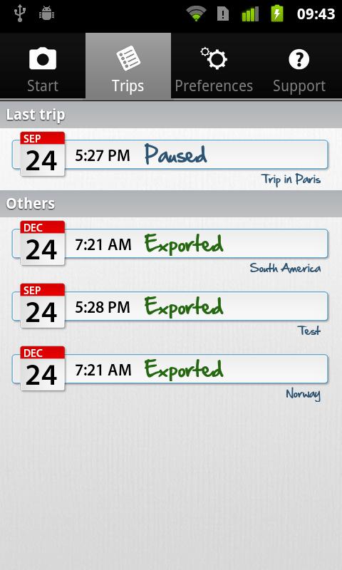
Been using this since it was first released, latest version makes gpx export on tablet easy.

We just need a way to make it work without data connection so I can use it when traveling without data roaming

Great app for recording photo positions via GPS if you are a photographer that will stop and crate a photo. Simple to use and has very useful automation and sync features. The down side is it would have failed miserably on my recent tour bus excursion shooting while moving through the city and later trying to identify the buildings and features from the GPS positions. 30 second granularity, with a few missed reads due to lack of GPS around tall dense buildings, could have put my GPS point miles away. This is not a recorder for photographers moving fast. I will return to the My Tracks app.

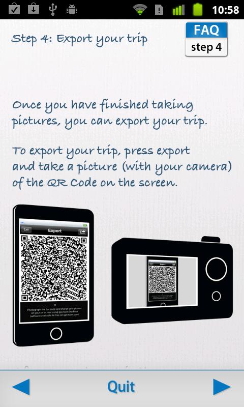
When photographing qr code at the end, the photo HAS to be crystal sharp, even more sharp than all my landscapes I took today. Desktop cant see any of my qr photos due to "too blurry" ? Maybe I should use a tripod?!

Very useful app. I am doing a report on some buildings in my country, I needed that app. Bravo.

Read more App Reviews