🌐 website

Flight Map at Google Play market analyse

App power index: 100 (based on ranks around App Stores today)
Transportation Maps & Navigation
Developer: Makro Productions
Price: $ 0.99
Current version: 1,000+, last update: 2 years ago
First release : 01 Jan 1970
App size: 23 Mb
4.8 ( 7248 ratings )

Estimation application downloads and cost

> 2.2k
Monthly downloads
~ $ 900
Estimation App Cost


YOU CAN DO IT ON A PLANE!Flight Map is a unique application that works as your own personal flight tracker (Sky map) while flying in an airplane. It shows where you currently are, speed, altitude and some other information about your flight. You can check the Estimated Time of Arrival of your flight while you are sitting on a plane. You can see how far from the target airport you are. You can also see and name the landmarks on the way, so that you know what you see from your window.There are two more version of Flight Map - Flight Map FREE which you can try for free and see if it works on your device without some functionality and Flight Map HD which includes more detailed world map, but it comes at a price of consuming more space in your phones memory.Flight Map also displays visible and used GPS / GLONASS satellites, so you can use it as a GPS testing tool. The GPS function works when your phone is in airplane mode, because it does not broadcast any radio, it rather listens to the GPS satellites only.Features include:- Real time position of the plane on the map- Zoomable world map not dependent on a connection to internet- Your own personal flight tracker- Works when your phone is in Airplane mode, so it can be used anytime while in flight- Recording your route and sharing it on the internet- Database of world airports- Entering destination as longitude / latitude coordinates- Estimated Time to Destination and Time to Arrival depending on the plane type and position- Dark / Light skin- Metric / Imperial units- Multilanguage (currently English, Spanish, Portugese, French, Russian, Chinese, Vietnamese, Czech, Japanese, Korean, Polish, Hungarian)- Map can be fullscreen or split screen with real time flight data- GPS / GLONASS Satellites real time display depending on your device capabilities- Sunrise and sunset at present position- Line to destination can be shown or hidden- Altitude calculation calibrated either to sea level or destination altitudePlease note that Flight Map is heavily dependent on the quality of your devices GPS capabilities. If your device is capable of A-GPS (Assisted GPS), please run the application while on the ground, so that the satellites positions get downloaded from the internet, it will be much easier for the device to pick up signal when in the air. Please share your experience with various devices. Most of the time Flight Map works perfectly when sitting in a window seat and does not work too good when sitting two seats from the window or more. In any case we recommend to move the device to the window, let it pick up the satellites signal first and then try how far from the window it can pick up the signal. The screen showing the visible and used satellites is designed to help you with this.If your device is capable of receiving GLONASS signal, the satellites are shown with a differently colored border. If you want to translate Flight Map into your language (or correct our translation), please contact the developer. The first run of the application takes a while because it needs to unpack the whole world map to be able to display it.Polish translation thanks to Tomasz PrycaHungarian translation thanks to Dr. Istvan LunczerVersion 1.4.1- fixed bug to track plane even without destination selectedVersion 1.4.0- fixed bug with not remembering plane type- fixed bug preventing from landscape layout - added input lat / lon coordinates for destination- routes recorded do not get deleted when upgrading - added Hungarian language - thanks to Dr. Istvan Lunczer for translation- Small plane model now estimates ETA based on actual speed

Latest version Flight Map: 1,000+

Version 1.4.1- fixed bug to track plane even without destination selectedVersion 1.4.0- fixed bug with not remembering plane type- fixed bug preventing from landscape layout - added input lat / lon coordinates for destination- routes recorded do not get deleted when upgrading - added Hungarian language - thanks to Dr. Istvan Lunczer for translation- Small plane model now estimates ETA based on actual speed

Apps Changes History:
  • New App Version 0 -> 0
  • New App Version 0 -> 0
  • New App Version 0 -> 0
  • New App Version 0 -> 0
  • New App Version 0 -> 0
  • New App Version 0 -> 0

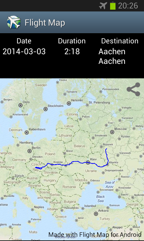
Now I can check the eta for my flight. And it's a amazing that all airports I need are there

Very good app, but map does not seem to zoom-in close enough.

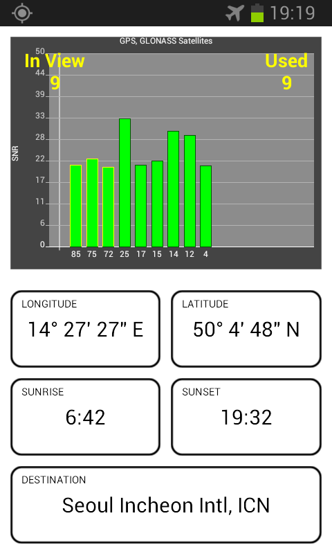
I just used this on 4 flights this past week. It does need to be close to window to pick up the most satellites so it maintains a constant signal. I think it was darn accurate in speed and altitude, based on what our intended altitude was going to be. It kind of freezes when you have too few satellites locked on, but moving it closer to window takes care of that. Enjoyed this aviation tracker, especially in legal "airplane mode".

Map is far too small to view any detail

By the description this should work on an airline flight with phone in airplane mode. The only position shown was while I was on the ground at EWR, did not work at all throughout the flight, showed me on the ground at Newark for my whole flight to Florida. A waste!

Nice update! Like the app so far, some suggestions for future features: -Still would like an option to delete / add blank to destination. :) (Route recording could be optional anyway.) -A nice feature would be to be able to use coordinates as DD°MM.MM' as well. -Maybe one further zoom level as an option for those with large internal memory. (At least for selected regions.) -Selectable aircraft icon on map. -Keep it up, pretty soon it will be 5* ;)

Best affordable offline flight mapper

Read more App Reviews