

Wasatch Backcountry Skiing Map

4.0star
46 reviews
1K+
Downloads

Everyone
info


About this app
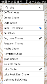
The Wasatch Backcountry Skiing Map (WBSkiing) is the Android version of the popular paper map and website (see https://WBSkiing.com). As with the other platforms, the Android map includes an index to more than 1,000 backcountry locations in Utah’s Central Wasatch mountains. It is the must-have map for Utah hikers and backcountry travelers.
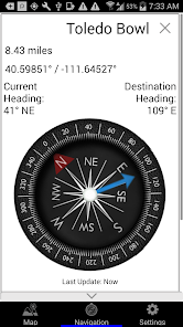
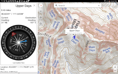
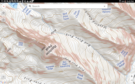
With a familiar interface, the Wasatch Backcountry Skiing Map accesses your device’s GPS to display your current location on a high-resolution topo map. And with only a few taps, the “destination arrow” on the integrated compass will point to your desired backcountry ski location. The map has "reddish" shading on slopes that are approximately 30 degrees or steeper. This shading will help you reduce your exposure when in avalanche terrain.
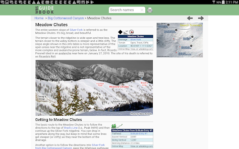
The app also displays your current elevation, latitude/longitude, and will send your current location via email. The app also links more than 200 of the locations to https://wbsguide.com where you can learn about the skiing difficulty, skinning distance, vertical climb, parking considerations, and more.
You do not need to have cell service to use this app--you don't even need a contract with a cell service provider.
If you encounter a problem with this app, PLEASE contact me using the support link (or via https://WBSkiing.com) before leaving a negative review.
With a familiar interface, the Wasatch Backcountry Skiing Map accesses your device’s GPS to display your current location on a high-resolution topo map. And with only a few taps, the “destination arrow” on the integrated compass will point to your desired backcountry ski location. The map has "reddish" shading on slopes that are approximately 30 degrees or steeper. This shading will help you reduce your exposure when in avalanche terrain.
The app also displays your current elevation, latitude/longitude, and will send your current location via email. The app also links more than 200 of the locations to https://wbsguide.com where you can learn about the skiing difficulty, skinning distance, vertical climb, parking considerations, and more.
You do not need to have cell service to use this app--you don't even need a contract with a cell service provider.
If you encounter a problem with this app, PLEASE contact me using the support link (or via https://WBSkiing.com) before leaving a negative review.
Updated on
Safety starts with understanding how developers collect and share your data. Data privacy and security practices may vary based on your use, region, and age. The developer provided this information and may update it over time.

No data shared with third parties
Learn more about how developers declare sharing

No data collected
Learn more about how developers declare collection
Ratings and reviews
4.0
45 reviews

Spencer Reynolds
- Flag inappropriate
January 15, 2025
The map is not very high resolution, and the app is just that, a topo map. Happy to support UAC, but this app is not useful, would love to see routes/info about areas or something more than just a map. Recommend Trailforks or OnX for app functions and viewing GPS location/topo info, will be purchasing a physical topo map in place of this.

A Google user
- Flag inappropriate
March 14, 2020
This app is great for the area it is intended to serve. (The Cottonwoods and surrounding drainages.) I have not had issues with the navigation dot and I use it often while out on tours to confirm location. Accurate in the field and that's all I'm asking it for. Works with the phone in airplane mode as well.
5 people found this review helpful

Cole Feagler
- Flag inappropriate
- Show review history
January 15, 2023
Fulfills its function & helps a ton with trip planning and while skinning. Would be five stars, except for lack of rotation support on Android (GS10+ with latest updates to phone & app). I have not encountered any issues with maps failing to load, search function, etc. However, sometimes it takes a few extra seconds for the map to display. Developers - keep up the good work. In your next update, any chance you could add some granularity to the slope shading feature?
1 person found this review helpful
What’s new
Version 5.0.1 fixes a few minor issues.
App support
About the developer
Iterum, LLC
info@iterum.com
6154 S Oak Canyon Dr
Salt Lake City, UT 84121
United States
+1 801-273-7478