
Estimation application downloads and cost
Description
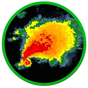
RadarScope is a specialized display utility for weather enthusiasts and meteorologists that allows you view NEXRAD Level 3 and Super-Resolution radar data along with Tornado, Severe Thunderstorm, Flash Flood Warnings, and predicted storm tracks issued by the U.S. National Weather Service. It can display the latest reflectivity, velocity, dual-polarization, and other products from any NEXRAD or TDWR radar site in the United States, Guam and Puerto Rico, as well as reflectivity and velocity data from Environment Canada radars, and two radars in South Korea. These aren't smoothed PNG or GIF images, this is native radar data rendered in its original radial format for a high level of detail. Whether you are scanning reflectivity for a mesocyclone's tell-tale hook echo, trying to pinpoint the landfall of a hurricane's eye wall, or looking for small features like velocity couplets in the storm relative radial velocity product, RadarScope gives you the power to view true radial NEXRAD weather radar on your Android device.RadarScope displays tornado, severe thunderstorm, and flash flood warnings issued by the U.S. National Weather Service. When warnings are in effect, you can tap the warning button in the upper right corner to browse the list of active warnings, select a warning to view the details, and even zoom to the selected warning on the map. (Not available in Canada).
Pinch or stretch to zoom in and out. Drag your finger around the map to scroll. Tap the radar sweep button in the toolbar to switch radars. Select one of the 156 different NEXRAD radar sites and 45 Terminal Doppler radars in the US, 30 other radar sites in Canada, and 2 in the Republic of Korea. Plot your current location by tapping the location button and optionally report it to the Spotter Network. Tap the play button to download and animate over recent images. Display the names of over 25,000 cities and towns on the map as you zoom and scroll. Tap and hold the color legend to see the data values. Meanwhile, RadarScope will retrieve and display updated data automatically and intelligently (approximately every 2 to 10 minutes, depending on the radar scan strategy).
You can display data from NOAA's public access web site, our optional WDT feed (the default), or your AllisonHouse subscriber account. Spotter Network members can report their location and view the locations of other spotters.
The RadarScope Pro subscription is an optional add-on data set. It provides access to real-time lightning data that animates along with the radar loop and up to 20 frames of radar data, including *extended loops* of Super-Res Level 2 data. Super-Res Level 2 data is still available to all RadarScope users without purchasing a subscription.
RadarScope Pro subscribers can also access a data interrogation tool to quickly determine data values for specific radar pixels and an optional dual-pane mode for viewing two radar products side-by-side.
Please visit our web site for more information.
Read more
Pinch or stretch to zoom in and out. Drag your finger around the map to scroll. Tap the radar sweep button in the toolbar to switch radars. Select one of the 156 different NEXRAD radar sites and 45 Terminal Doppler radars in the US, 30 other radar sites in Canada, and 2 in the Republic of Korea. Plot your current location by tapping the location button and optionally report it to the Spotter Network. Tap the play button to download and animate over recent images. Display the names of over 25,000 cities and towns on the map as you zoom and scroll. Tap and hold the color legend to see the data values. Meanwhile, RadarScope will retrieve and display updated data automatically and intelligently (approximately every 2 to 10 minutes, depending on the radar scan strategy).
You can display data from NOAA's public access web site, our optional WDT feed (the default), or your AllisonHouse subscriber account. Spotter Network members can report their location and view the locations of other spotters.
The RadarScope Pro subscription is an optional add-on data set. It provides access to real-time lightning data that animates along with the radar loop and up to 20 frames of radar data, including *extended loops* of Super-Res Level 2 data. Super-Res Level 2 data is still available to all RadarScope users without purchasing a subscription.
RadarScope Pro subscribers can also access a data interrogation tool to quickly determine data values for specific radar pixels and an optional dual-pane mode for viewing two radar products side-by-side.
Please visit our web site for more information.
RadarScope screenshorts